
LESSON PLAN:
Where in the World War?: Mapping the Geography of D-Day
For the soldier coming ashore on D-Day the ability to read a map accurately could mean the difference between life and death. Deciphering a map today is less deadly but is still an important skill. Students, however, still need to learn how to read maps for the historical information they can provide. This map-reading exercise will require students to understand scale, a legend, iconography, national flags, and western European geography.
Objective:
Students will analyze a map of the D-Day invasion of Normandy and answer questions relating to their analysis.
Grade Level: 7-12
Standards:
History Thinking Standard 2—the student comprehends a variety of historical sources and can draw upon historical maps in order to obtain or clarify information on the geographic setting in which the historical event occurred
Content Era 8 (1929-1945), Standard 3B—the student understands World War II and how the Allies prevailed.
Time Requirement: One class period.
Download a printable pdf version of this lesson plan
Directions:
1. Use the map transparency provided for this activity.
2. After presenting a lesson on the history of D-Day (you may use the included D-Day Fact Sheet), review the map with students pointing out the different elements of the map.
3. Have students fill out the question sheet.
4. Hold a brief discussion about the map: What elements of this map do the students like? What parts are confusing? What information is not on this map that could be? Are the design elements of the map appropriate (colors, shapes, icons, etc.)?
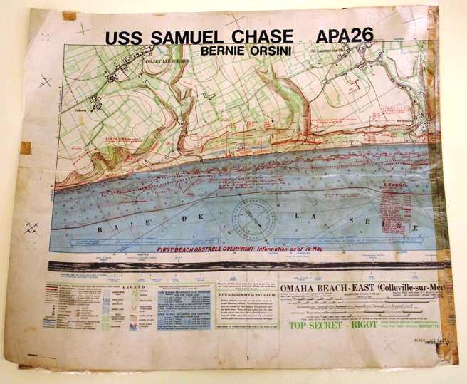
5. After the discussion, look at the picture of the cloth map of Omaha Beach. This is a map a soldier would have carried with him onto the beach during the Normandy invasion. What important information is on the map? What is the purpose of the map? Do you find the map difficult to read? Why of why not? Why does the map have “Top Secret” written along the bottom? What does this map tell us about the dangers and complications the Allies faced in the invasion?
Assessment:
Components for assessment include the completed student worksheet and class discussions.
Enrichment:
Have students research and create a historical map of another WWII battle: the attack on Pearl Harbor, Midway, The Battle of the Bulge, etc. Display these maps on the wall.
Maps
Discussion Questions
Map Questions (you may need to consult another map to answer question 13)
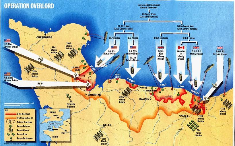
1. How many U.S. divisions took part in the D-Day invasion of Normandy? Name them.
2. How many British divisions took part in the D-Day invasion of Normandy? Name them.
3. How many Allied divisions in total took part in the invasion?
4. What beach did the Canadians assault?
5. Which two major Normandy towns had the Allies captured by June 12?
6. Approximately how many miles is the length of the entire invasion area?
7. To get from Normandy to Paris you must travel in which direction?
8. What geographical obstacle kept the 21st Panzer Division from attacking the Allies on D-Day?
9. Which beach had the smallest Allied advance of D-Day?
10. Which town did U.S. Airborne troops capture?
11. To get to London from Normandy you must travel in which direction?
12. Can you determine how many miles the Allied armada traveled across the English Channel? Explain.
13. Parts of three countries are shown on this map. What are they?
14. From this map, can you tell if Hitler’s Atlantic Wall was a success? Explain.
Answer Sheet
1. Five divisions: 1st Infantry, 4th Infantry, 29th Infantry, 82nd Airborne, 101st Airborne
2. Three divisions: 50th Infantry, 3rd Infantry, 6th Airborne
3. Nine divisions
4. Juno Beach
5. Carentan and Bayeux
6. 60 miles or 90 kilometers
7. East or southeast
8. Orne River
9. Omaha
10. Ste. Mere-Eglise
11. North
12. Two possible answers: No—the scale of miles on the map is not scaled for the inset map. Yes—use the scale of miles on the map to determine the length of the Normandy invasion area, and then use that length as a new scale of miles on the inset map.
13. Great Britain, France, Belgium (in the inset map)
14. Hitler’s Atlantic Wall was not a success because the Allied armies were able to breach it within one day.
Download a printable pdf version of this lesson plan
TAKE ACTION:


EDUCATION PROJECTS:
Student Travel – WWII Educational Tours
High school and college students, learn the leadership principles that helped win WWII on a trip to France or during a weeklong residential program in New Orleans. College credit is available, and space is limited.
See You Next Year! HS Yearbooks from WWII
Collected from across the United States, the words and pictures of these yearbooks present a new opportunity to experience the many challenges, setbacks and triumphs of the war through the eyes of America’s youth.
The Victory Gardens of WWII
Visit the Classroom Victory Garden Project website to learn about food production during WWII, find lesson plans and activities for elementary students, get tips for starting your own garden and try out simple Victory Garden recipes!
The Science and Technology of WWII
Visit our new interactive website to learn about wartime technical and scientific advances that forever changed our world. Incorporates STEM principles to use in the classroom.
Kids Corner: Fun and Games!
Make your own propaganda posters, test your memory, solve puzzles and more! Learn about World War II and have fun at the same time.
